SSLR Maps Online 2025 Village Map Karnataka
Check Online SSLR Maps 2025 of Karnataka from Bhoomi RTC Portal. Follow the simple steps mentioned below and download the Revenue Maps service provider in a PDF file.
Available Services on SSLR Maps
Following maps are available on Bhoomi Online Portal.
Why are revenue maps important in Karnataka?
For property verification, urban planning, and resolving the disputes of land in Karnataka these maps play a very important role. Exact and authentic information about land boundaries, ownership and utilization of land can be obtained from these maps. These online sslr revenue maps are very important tools for government agencies to ensure adequate land management, while for businesses they act as a foundation for making well-informed decisions and for citizens of Karnataka state they are crucial in protecting their property rights and helping to avoid disputes.
Accessing SSLR Revenue Maps Online: A Comprehensive Guide
To understand the land record details in Karnataka, SSLR (Survey Settlement and Land Records) revenue maps play very vital role. You can use Bhoomi Online portal to access the SSLR maps and find the details about land ownership verification, resolving the disputes, and helping in infrastructure development. This article provides the in depth details of SSLR revenue maps, their types, how to access them, and their usage.
Understanding SSLR Revenue Maps
SSLR revenue maps provide detailed representations of land parcels. The primary types of maps include:
| SSLR Map Type | Description |
|---|---|
| Cadastral Maps | These are the detailed maps giving information about individual land parcels |
| BBMP Maps | These maps contain information about Bruhat Bengaluru Mahanagara Palike (BBMP) area. |
| Lake Maps (Digital) | Digital representations of lake areas for environmental and planning needs. |
| Lake Maps (Survey) | Surveyed maps providing detailed lake boundaries and data. |
| Survey Details | Additional information related to land surveys and ownership. |
Revenue Maps Webpage
- To access Cadastral Map, BBMP, Lake (Digital, Survey), Survey Details and other services. Please click https://landrecords.karnataka.gov.in and select Revenue Maps option from SSLR Services.

Cadastral Map (Village Map)
- To check the Cadastral (Village) Map, click the State Tab, then choose your District, Taluk, Hobli, and Map type. After choosing these options provide your village name and click Search.
- As a result of this, your screen will display the village list. Simply click on the PDF file icon in front of your village.

- You will see a PDF file of your village map, which can be printed or downloaded.

BBMP Map
- To check the BBMP map, click the BBMP Tab, select your Ward, enter your village name, and hit the Search button.
- After that, you will see a list of villages, just click on the Map icon in front of your village.

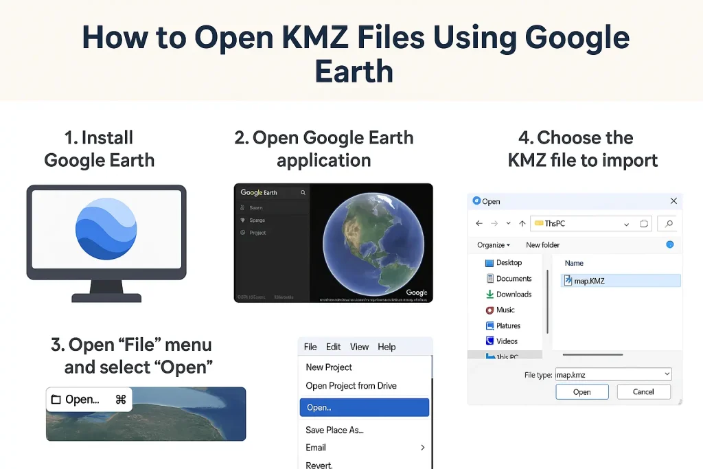
- To get the KMZ file, you will need to have Google earth to open it. Open google earth and chose File tab, then import the KML/KMZ file. Now, you can view the BBMP map through google earth.

Lake Map (Digital)
- To check the digital lake map, first click on the lake (Digital) Tab, then search your village. As a result, the village list will appear on the screen. Just click the JPEG file next to your village name.

- Once you open the JPEG file, you can view Digital Lake map on your screen which you can print or download as per your need.

Lake Map (Survey)
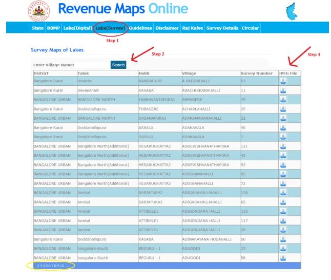
To view the Survey Lake Map, hit the Lake (Survey) tab, and then search your village. Now,you will see the village list on your screen. Just click the JPEG file icon next to your village

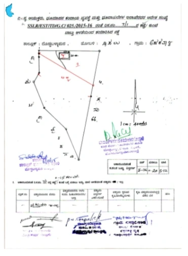
Once you click the JPEG file, your survey lake map will appear on your screen, which you can download or print as required.

Practical Applications of SSLR Revenue Maps
SSLR revenue maps are invaluable for several use cases:
- Resolving Land Disputes: Detailed boundaries help resolve conflicts over land ownership.
- Land Ownership Verification: Useful for property transactions and legal purposes.
- Agricultural Planning: Identifying land suitable for farming or irrigation projects.
- Urban Development: Assisting in infrastructure projects and city planning.
- Environmental Protection: Mapping lakes and other natural resources for conservation efforts.
How to Open KMZ Files Using Google Earth (With Visual Guide)
Follow these simple steps to Open SSLR or BBMP maps in .kmz format . These files help visualize land parcels on satellite imagery. Follow these steps below:
✅ Step 1: Download Google Earth
➡️ Go to the official Google Earth website: https://www.google.com/earth/
Choose the platform that suits you — Windows, Mac, Android, or iOS — and install it.
✅ Step 2: Download the KMZ File from SSLR/Bhoomi Portal
- Go to the SSLR map section on their official site.
- Select your district, taluk, and village, then download the
.kmzmap file.
📝 Tip: Make sure the file ends in .kmz – that’s the format readable by Google Earth.
✅ Step 3: Open the KMZ File in Google Earth
💻 On Desktop:
- Open Google Earth.
- Click on File > Open.
- Select the
.kmzfile you downloaded.
📱 On Mobile:
- Open the Google Earth app.
- Tap the menu (☰) and choose Projects > Open > Import file.
- Browse and select the
.kmzfile.
✅ Step 4: Explore the Land Map Visually
Once the map loads, you’ll see boundary lines, plot numbers, landmarks, and roads layered over satellite imagery. You can zoom in, rotate the view, or click on individual parcels for more details.
🧭 Use the navigation tools on the side to tilt, zoom, or pan around your area.
🖼️ Infographic for Visual Learners

How to Read and Understand SSLR Village Maps
Once you’ve downloaded and opened your map, follow these simple steps to read and understand it.
🔲 1. Plot Numbers / Survey Numbers
Each land parcel will have a number written inside its boundary. This is the Survey Number — a unique ID for that land plot.
📌 This number can be used for :
- Cross-check land ownership in RTC (Pahani)
- Resolve disputes or verify boundaries
🛣️ 2. Boundary Lines
- Thick Black Lines: These lines show Village or Hobli boundaries
- Thin Lines: Individual land parcel boundaries are shown by thin lines
- Dashed Lines: Dashed lines are used for Pathways, internal roads, or unregistered paths
🔍 If the boundary of a plot looks uneven, it could mean the land is shared or the survey is old.
🌊 3.Water Bodies & Government Land
- Blue shaded areas = Lakes or water tanks
- Gray or green = Government-owned land, sometimes marked with “G” or “Govt”
These areas are non-purchasable and often come under government regulation.
🚨 Common Mistakes to Avoid While Reading Maps
✅ Don’t assume two nearby plots are one just because they look connected.
✅ Always check the survey number with the RTC (Record of Rights).
✅ If a plot number is missing or overlapped, it could be due to an outdated map — always ask for the latest map.
FAQs
Conclusion
SSLR maps are a useful resource for individuals, farmers, developers, and policymakers. By following the steps explained above, you can easily access and utilize these maps for required purposes. For more information, visit the official Bhoomi Online portal and explore its range of services.